Ho Chi Minh Trail

Ho Chi Minh trail 

The Hồ Chí Minh trail (also known in Vietnam as the “Trường Sơn trail”) was a logistical system that ran from the North Vietnam to the South Vietnam through the neighboring kingdoms of Laos and Cambodia.

It was named by the Americans after North Vietnamese president Hồ Chí Minh. Although the trail was mostly in Laos, the communists called it the Trường Sơn Strategic Supply Route (Đường Trường Sơn), after the Vietnamese name for the Annamite Range mountains in central Vietnam. According to the United States National Security Agency’s official history of the war, the Trail system was “one of the great achievements of military engineering of the 20th century.”

The Ho Chi Minh Trail was not just one trail but a series of trails. The Ho Chi Minh Trail was used by the North Vietnamese as a route for its troops to get into the South. They also used the trail as a supply route – for weapons, food and equipment. The Ho Chin Minh Trail ran along the Laos/Cambodia and Vietnam borders and was dominated by jungles. In total the ‘trail’ was about 1,000 kilometres in length and consisted of many parts.

“There were thousands of trails, thousands of rest spots along the way where enemy troops could seek refuge and build up.”

The ‘trail’ consisted of dummy routes that served the only purpose of confusing the Americans but was, in places, 80 kilometres (50 miles) wide. It is thought that up to 40,000 people were used to keep the route open. The natural environment gave the trail excellent cover as the jungle could provide as much as three canopies of tree cover, which disguised what was going on at ground level. The American response to this was to use defoliants – the most famous being Agent Orange – to kill off the greenery that gave cover to those using the trail. However, while large areas of jungle were effectively killed off, the task was too great and the Ho Chi Minh Trail was used for the duration of the war against the Americans in South Vietnam.

One way for the Americans to counter the Ho Chi Minh Trail was to build large bases near to it – Khe Sanh was one of these. From these large bases patrols were sent out in an effort to intercept anyone using the route. Regardless of this, it does seem that the task was simply too great for the Americans. Whereas the trail was based on deception and fluidity, the military bases built by the US were static. Therefore, once patrols left these bases they were by themselves. While they could be supported by air, there would always be a time delay between combat on the ground and the arrival of air support. By the very nature of guerrilla warfare, this gave the North Vietnamese the advantage as they had the ability to disappear into the jungle.

Ho Chi Minh Trail, elaborate system of mountain and jungle paths and trails used by North Vietnam to infiltrate troops and supplies into South Vietnam, Cambodia, and Laos during the Vietnam War. The trail was put into operation beginning in 1959, after the North Vietnamese leadership decided to use revolutionary warfare to reunify South with North Vietnam. Accordingly, work was undertaken to connect a series of old trails leading from the panhandle of North Vietnam southward along the upper slopes of the Annamese Cordillera (French: Chaîne Annamitique; Vietnamese: Truong-Son) into eastern Laos and Cambodia and thence into South Vietnam. Starting south of Hanoi in North Vietnam, the main trail veered southwestward to enter Laos, with periodic side branches or exits running east into South Vietnam. The main trail continued southward into eastern Cambodia and then emptied into South Vietnam at points west of Da Lat.

The network of trails and volume of traffic expanded significantly beginning in the 1960s, but it still took more than one month’s march to travel from North to South Vietnam using it. Traffic on the trail was little affected by repeated American bombing raids. Efforts were gradually made to improve the trail, which by the late 1960s could accommodate heavy trucks in some sections and was supplying the needs of several hundred thousand regular North Vietnamese troops active in South Vietnam. By 1974, the trail was a well-marked series of jungle roads (some of them paved) and underground support facilities such as hospitals, fuel-storage tanks, and weapons and supply caches. The Ho Chi Minh Trail was the major supply route for the North Vietnamese forces that successfully invaded and overran South Vietnam in 1975.

Hanoi to Phong Nha

Hanoi to Phong Nha
Travel from Hanoi to Phong nha – Vietnam

Many options exist for travel to and from Phong Nha via bus and the cheapest and most convenient way of getting from Hanoi to Phong Nha is by sleeper bus Busses depart from Dong Hoi, Hanoi, Hue, Danang, Ninh Binh and many other smaller destinations …

Transport information and advice for Phong Nha. Includes timetable, You can book this bus at Phong Nha Caves Tours

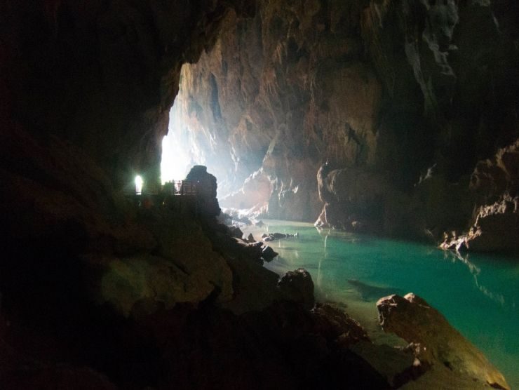
Phong Nha-Kẻ Bàng national park is home to the largest cave in the world and covers 300 different grottoes and caves. Phong Nha Cave was regarded by British Caving Association as the top cave in the world due to its top four records: the longest underground river, the highest and longest cave, broadest and most beautiful fine sand beaches inside the caves, and the most spectacular stalagmites and stalactites. In the survey conducted in April 2009, the British cave explorers discovered 20 new caves with total length of 56 km, including world’s largest cave Thien Duong. According to the assessment of UNESCO, “The karst formation of Phong Nha-Kẻ Bàng National Park has evolved since the Palaeozoic (some 400 million years ago) and so is the oldest major karst area in Asia” and “Phong Nha displays an impressive amount of evidence of earth’s history. It is a site of very great importance for increasing our understanding of the geologic, geomorphic and geo-chronological history of the region.

Hoian to Phong Nha

Hoian to Phong Nha


Phong Nha–Kẻ Bàng National Park is located in the territories of communes, Tan Trach, Thuong Trach, Phuc Trach, Xuan Trach and Son Trach of Bố Trạch District and a small part of Minh Hóa District in the center of Quảng Bình Province, around 40 km north-west of the provincial capital city of Đồng Hới. The park is bordered by the Hin Namno karst area of Khammouane Province of Laos in the west. Road distances are about 500 km south of the capital Hanoi and 260 km north of the port city of Đà Nẵng. The geographical coordinates are 17°32′14″N 106°9′4.5″E.

The park is situated around 30 km west of the South China Sea and National Route 1A, near Hồ Chí Minh Highway and 28 km west of the Hanoi–Saigon Railway, and is accessible by road or waterway through an estuary in the South China Sea. There is a small airport near the park accessible by helicopter or small aircraft (Khe Gat Airbase), an airbase used by the North Vietnamese Air Force during the Vietnam War, notably in the Battle of Đồng Hới.

Da Nang to Phong Nha

Travel from Da Nang to Phong Nha


Phong Nha–Kẻ Bàng National Park is located in the territories of communes, Tan Trach, Thuong Trach, Phuc Trach, Xuan Trach and Son Trach of Bố Trạch District and a small part of Minh Hóa District in the center of Quảng Bình Province, around 40 km north-west of the provincial capital city of Đồng Hới. The park is bordered by the Hin Namno karst area of Khammouane Province of Laos in the west. Road distances are about 500 km south of the capital Hanoi and 260 km north of the port city of Đà Nẵng. The geographical coordinates are 17°32′14″N 106°9′4.5″E.

The park is situated around 30 km west of the South China Sea and National Route 1A, near Hồ Chí Minh Highway and 28 km west of the Hanoi–Saigon Railway, and is accessible by road or waterway through an estuary in the South China Sea. There is a small airport near the park accessible by helicopter or small aircraft (Khe Gat Airbase), an airbase used by the North Vietnamese Air Force during the Vietnam War, notably in the Battle of Đồng Hới.

Phong Nha Vietnam

Phong Nha Caves Vietnam

Phong Nha-Kẻ Bàng national park is home to the largest cave in the world and covers 300 different grottoes and caves. Phong Nha Cave was regarded by British Caving Association as the top cave in the world due to its top four records: the longest underground river, the highest and longest cave, broadest and most beautiful fine sand beaches inside the caves, and the most spectacular stalagmites and stalactites.


In the survey conducted in April 2009, the British cave explorers discovered 20 new caves with total length of 56 km, including world’s largest cave Thien Duong.  According to the assessment of UNESCO, “The karst formation of Phong Nha-Kẻ Bàng National Park has evolved since the Palaeozoic (some 400 million years ago) and so is the oldest major karst area in Asia” and “Phong Nha displays an impressive amount of evidence of earth’s history. It is a site of very great importance for increasing our understanding of the geologic, geomorphic and geo-chronological history of the region.

Train to Phong Nha

Travel from Hanoi to Phong nha – Vietnam by train

Travel to Phong Nha with many options exist for travel to and from Phong Nha train and the cheapest and most convenient way of getting from Hanoi to Phong Nha is by train depart from Dong Hoi, Hanoi, Hue, Danang, Ninh Binh and many other smaller destinations …

Transport information and advice for Phong Nha. Includes timetable, You can book tickets at Phong Nha Caves Tours

Phong Nha-Kẻ Bàng national park is home to the largest cave in the world and covers 300 different grottoes and caves. Phong Nha Cave was regarded by British Caving Association as the top cave in the world due to its top four records: the longest underground river, the highest and longest cave, broadest and most beautiful fine sand beaches inside the caves, and the most spectacular stalagmites and stalactites. In the survey conducted in April 2009, the British cave explorers discovered 20 new caves with total length of 56 km, including world’s largest cave Thien Duong. According to the assessment of UNESCO, “The karst formation of Phong Nha-Kẻ Bàng National Park has evolved since the Palaeozoic (some 400 million years ago) and so is the oldest major karst area in Asia” and “Phong Nha displays an impressive amount of evidence of earth’s history. It is a site of very great importance for increasing our understanding of the geologic, geomorphic and geo-chronological history of the region.

Phong Nha Farmstay

Phong Nha Farmstay

consists of many useful information for your trip and your stay in Phong Nha, Quang Binh province, Vietnam

Phong Nha-Kẻ Bàng national park is home to the largest cave in the world and covers 300 different grottoes and caves. Phong Nha Cave was regarded by British Caving Association as the top cave in the world due to its top four records: the longest underground river, the highest and longest cave, broadest and most beautiful fine sand beaches inside the caves, and the most spectacular stalagmites and stalactites. In the survey conducted in April 2009, the British cave explorers discovered 20 new caves with total length of 56 km, including world’s largest cave Thien Duong. According to the assessment of UNESCO, “The karst formation of Phong Nha-Kẻ Bàng National Park has evolved since the Palaeozoic (some 400 million years ago) and so is the oldest major karst area in Asia” and “Phong Nha displays an impressive amount of evidence of earth’s history. It is a site of very great importance for increasing our understanding of the geologic, geomorphic and geo-chronological history of the region.

.